13th September. Today
was a free day so we got the washing done and rested. The afternoon was not real good as I had a
bit of a Meniere’s wobbly time and it wasn’t very pleasant.
We also received word tonight that our dear
friend Wayne Adams has passed away. We
sent our deepest Sympathies to Marie and family at this very sad time.
14th September we took the car into the Goyder Auto Service
and Tony replaced the Turbo airhose for us.
Car runs great now. We then did a
drive to Clare, Penwortham and down to Kapunda and then up the Tothill Belt to
Black Springs road and then back to Burra.
At Penwortham we stopped off to see the John Horrocks’ Cottage c1839. This is the ‘oldest stone building in the States, north of Gawler. It was built by Joh Horrocks at the young age of 21’.
 John Horrocks cottage
 Happy Wanderer plant
 Darryl could just stand under the verandah
 scar tree
 Canola field
 Gazania's in Kapunda
 Wattle in Kapunda
 The Tothill Belt Road with the windfarm on the western side of the road up on the ridge
 Tothill Belt and Tothill Creek intersection
 Love that they must leave the old homes on the property until they disintergrate
 lovely dirt road. Was so smooth
 We went to the La Percora Pizzeria in Burra for dinner that night
The wind started to pick up this afternoon and
became very strong during the night.
Sat 15th. Today
is my brothers, Trevor and wife Karen, 28th wedding anniversary.
We didn’t do much today as we had very strong
winds (gusts up to 80kmph) and rain squalls.
Two other campers that were to pull out that morning decided that -- the
weather was not conducive to travel – and would pull out in the morning.
Sun 16th. Up
early and pulled out by 9am. We made our
way down the Barrier Highway (missed out turn) and arrived at Saddleworth
before turning up to Auburn and then down towards Balaclava and on to Port
Wakefield. We arrived in Price at about
2pm. The wind had been picking up
gradually as we drove and we were getting hit from the westward side – so time
to pullover. The caravan park here has
mainly permanents with only 4 traveller
sites. By 6pm the sites were all
full and there was still the occasional squally shower. We went for a short drive out to the jetty on
Wills Creek and checked out the history.
 Loving the green and gold colours
 Welcome to Yorke Peninsula
 Price Wharf on Wills Creek
 Wills Creek at low tide
 where we were standing on at the end of the road that touches the red circle in bottom left of photo
 Salt waiting to be shipped out
 Tiddy Widdy Beach
 a field of Gazania's
 Darryl found a full array of MENZ sweets
 At Ardrossan headland
 One of the 'Walk the Yorke' picture-boards
 The cliffs of Ardrossan
 a resting seat on the 'Walk the Yorke' trail
 a sculpture in town
 One of the Oiled Greens at Ardrossan
 Another lovely old home
We then made our way back to the caravan and passed through two small rain squalls on the way.
Mon 17th I sent Darryl off to do some fishing. He said the wind wouldn’t bother him as it was coming from the north and would assist him in throwing the line across the creek. He was gone about 2 hours when he returned to say that the wind had changed direction and coming straight down the creek and throwing his line back at him – so he gave up. We went across the road to the pub for tea BUT they don’t cook on Monday or Tuesday – so back to the van and Darryl made a nice chicken and rice noodle soup instead.
Tuesday 18th. We were out of the van park by 9am and heading southward through Ardrossan, Curramulka, Minlaton, Hardwicke Bay to Warooka and then westward to Corny Point. Corny Point is ‘on the top of the boot’ of the Yorke Peninsula. Again the wind was picking up as we drove and we had a solid headwind as we pulled into the caravan park at about 11.30 and set up. The van park has got bore water to its taps and we were advised to not use this water for drinking. It has a lot of lime in it and would build up scale in the kettle. The mobile internet reception is also a bit hit and miss but thankfully they have free Wi-Fi in the camp kitchen. It still takes forever for messages to send.
This afternoon we went for a drive out to the lighthouse to the west and then down the west coast to Berry Bay.
 We had rain as we went through Hardwicke Bay
 The beach at Corny Point


Today we drove down to Gleesons Landing, Marion Bay, Stenhouse Bay and Innes National Park and then out via Foul Bay and Sturt Bay and up to Warooka. There are fees to get into the Innes National Park and the signs say it has to be booked on-line. They have a computer and keyboard outside the visitor centre and you use your credit card BUT if the centre is open the staff there will process your fee for you. It is $8 per vehicle per day or $15 per day to camp.
 A camping bay at Gleesons Landing
 Coastal Pigface
 yellow flower
 Anchor and Canons outside the Marion Bay History Society
 arty-farty boardwalk
 white flowering shrub
 Rhino Rock from the Stenhouse Bay info centre
 a Fowl in the info centre carpark
 nice
niceThe weather was great and the views magnificent. After stopping and looking at Marion Bay and then the Stenhouse Bay jetty and the Gypsum mine.
 Stenhouse Bay jetty with the Gypsum mine in top right
 pink purple
 orange
 Emu grazing on daisies
 View from West Cape lighthouse
 Coastal pigface flower
We stopped in and checked out the wrecks of the ‘Ethel’ and the ‘Ferret’ before making our way to Inneston Village
 boiler of the 'Ferret' on the beach
 Skeleton of the 'Ethel'
 arty-farty stump at Innes lake. The lake is salt water and below sea-level
 Post Office on the left has been restored, then the general store, then the bakehouse with the stables at the far right
 bakehouse ovens, that I think they use regularly as they are very clean with newish utensils

 wattle
 more wattle
 Emu's grazing at the Inneston village

 succulent with white flower
 cliffs at Cape Spencer lighthouse
 love the colour of the water
 Cape Spencer lighthouse
 button grass
 nice yellow daisy bush
 another yellow flower
We made our way back to Marion Bay and had
lunch at the café before heading north east towards Foul Bay. We pulled in to Meehans Hill lookout and noticed
that they had blocked off the road and made a new one and a small carpark. When you walk out to look at the scenery you
can see where most of the original carpark has fallen into the ocean.
At Foul Bay we found the water was just a
gentle ebb and flow and not the crashing waves that we had been seeing all
morning. It was the same when we arrived
at Sturt Bay. We then drove up to Warooka
and stopped for a coffee in the Take-away/Butchers shop. We also got some meat for dinner for the next
few evenings. When we came out you could
see a storm rolling in from the south west and the temperature had dropped
again. We stopped at Foodworks for
vegetables and came out to a very heavy rainstorm. We drove through 36km of rain to get back to
the caravan. We utilised the
camp-kitchen to cook our dinner this night.
Thursday 20th. Today
we drove eastward towards Point Turton.
We pulled up to the north on most of the off-shoots to the beaches.
Couch Beach was a small fishing/holiday village
and quite untidy, but the beach was nice.
The Pines was quite a decent sized village and
has a general store open 7 days a week. Driving
along the beachfront street you could not SEE the water but there were about 8 different
points where you could get through to the beach via a path. Quite a bit of seaweed washed up along the
beach with lots of cuttlefish.
 just about every where has tractors to put their boats into the water
 calm seas off Leven Beach
 a lovely succulent with a huge yellow flower
 succulent with red flower
Soutars Beach was lovely and clean and you could see out a fair distance.
 Darryl checking out the beach
  Purple flower down the middle of the track
 white flowers right down near the surf
 yellow and purple
 spiky purple flowers in a house garden at Point Turton
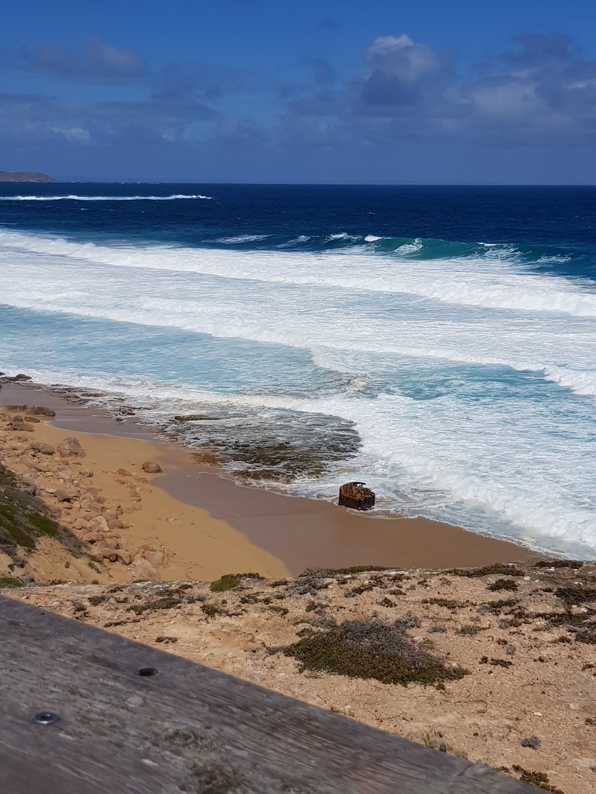
There is also a wreck in the harbour, not far out from the shore and 300 metres south-east of the jetty. You can see it by the metal boiler stack that sticks out of the water and has a big yellow X on top of it.
It is ‘The Yulta’, a steam tug that carried supplies from Adelaide to many ports around South Australia, which ran aground in 1926
 Point Turton jetty
 Clear water off the jetty
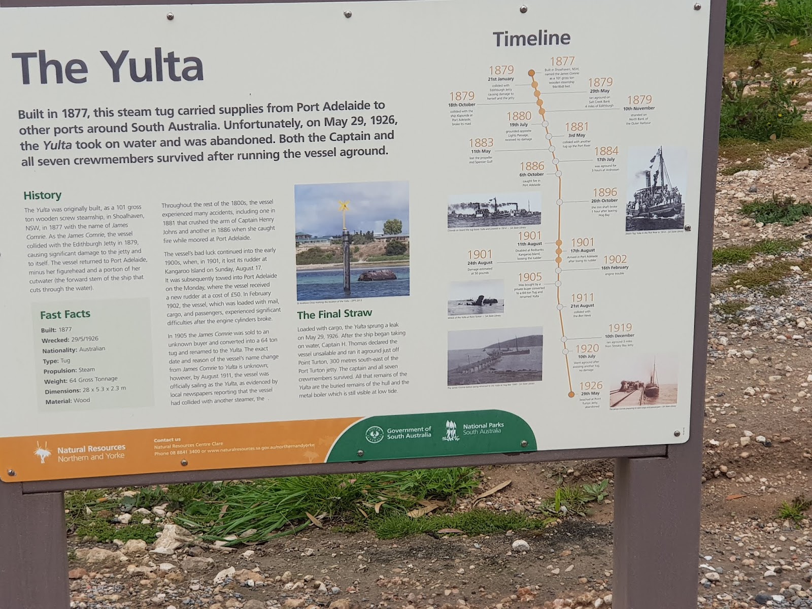 The Yulta picture board
 The steamer funnel out int he bay about 300 meters from the jetty
 Beach at Parsons Beach
 lots of these little shells are found along this part of the coastline
 shags on the rocks
We ventured through Hardwicke Bay and then up the west coast to Port Minlacowie and then Cockle Beach before going up to Parsons Beach and Bluff Beach.
At Bluff Beach they have davits in the cliffs where they used to store their boats, before the introduction of aluminium and fibreglass boats and boat trailers. These are an interesting construction of timber and shackles to raise the boats out of the water to store them safe. Unfortunately, in 1954 when a very bad storm wrecked 4 boats and washed away the beach shelter, the davits were not replaced. Two remain today but are deteriorating and are not used to store the boats.
 Explaining the 'davits' along the cliffs
 a remaining davit
 artwork in the gallery at Minlaton from beach wood
 a lovely melon-basket at the gallery
The weather was changing and the wind picking
up and coming from the north west.
We then made our way to Minlaton and visited
the Harvest Gallery Centre and Information Centre before topping up the fuel
and heading back to the van.
Friday 21st. A
lovely day today so have sent Darryl to do some fishing. I have done the washing and updated the blog. I have done some weaving and hope to attach
some of the small shells that I collected at Leven Beach yesterday.
I have been trying to get a message to go on
facebook for the past two days with no success due to the intermittent Telstra
reception. I think it starts with – this
is the third attempt……
Hoping that you are all keeping well.
No comments:
Post a Comment